

Weekend forecast: Chilly Saturday but much warmer Sunday with sunshine
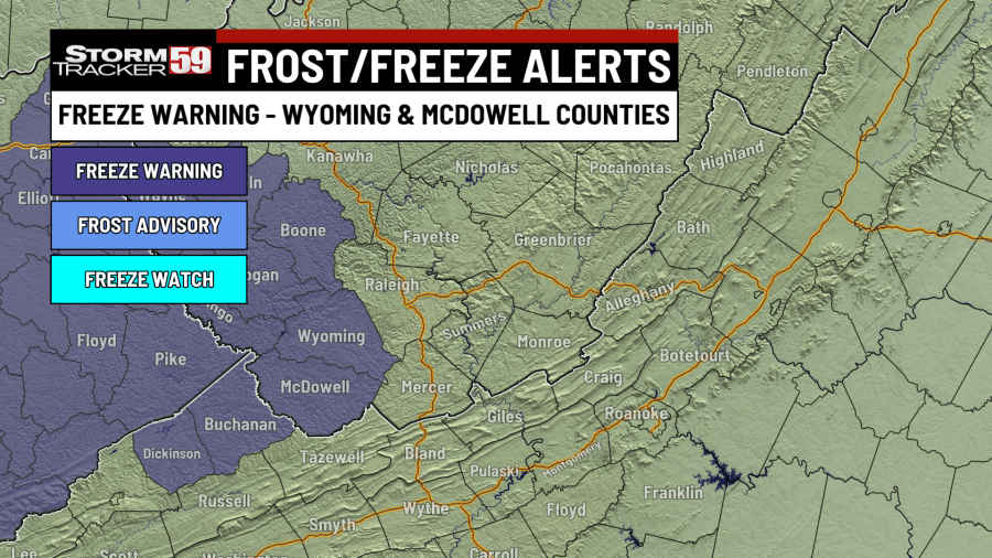
Alerts Issued for Our Region
- FREEZE WARNING for Wyoming and McDowell counties from midnight to 10 AM Saturday and also from Saturday night through Sunday morning. Temperatures expected to drop below freezing during both overnight timeframes could kill crops or other sensitive vegetation.
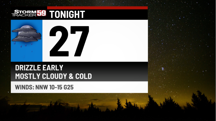
Tonight features light showers before midnight with otherwise mostly cloudy skies. We will see a slow clearing trend take place after midnight. A northwest wind that will be breezy at times will usher in much colder temperatures overnight with lows in the mid 20s. Wind gusts up to 25 mph are expected.
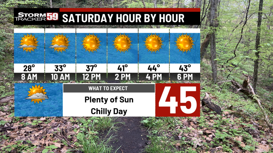
Saturday provides a few clouds in the morning, but we will see gradual clearing continuing throughout the morning and into the afternoon with mostly sunny skies expected. Despite the sunshine, it’s not much of a warmup expected with a north breeze in place as we’ll see high temperatures in the low to mid 40s.
Saturday night will see temperatures drop quickly initially with mostly clear skies, but our wind will begin to shift to coming from the southeast after midnight. As a result, our low temperatures will take place around midnight near 30 degrees and will slowly climb toward dawn. Ridgelines will be warmer than the valleys as a result of the cold air in place being forced to ‘sink’ down into the valleys.
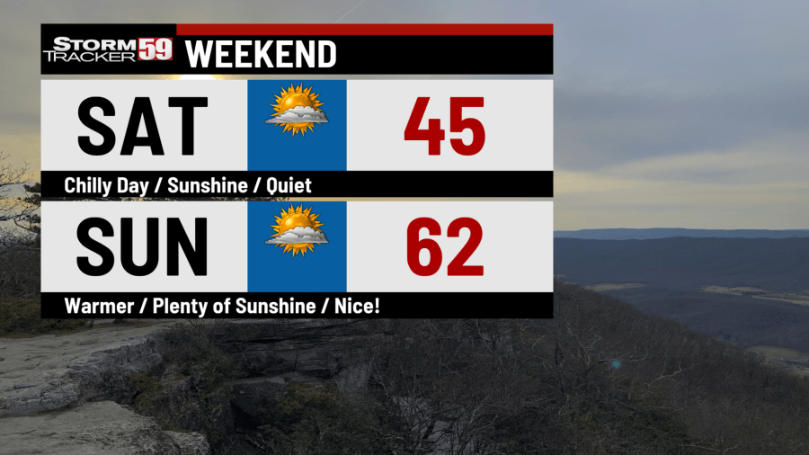
Sunday features more sunshine and warmer temperatures as high pressure moves due east of the region. That will get the southerly breeze kicking well and push high temperatures up into the low to mid 60s along and west of the turnpike/US-19 corridor, with 50s farther east into the Greenbrier Valley.
Monday sees a good fetch of moist air in the mid-levels surge northward from the Gulf. That will interact with a weak disturbance and provide clouds with a few lightly scattered showers. There will be more dry time than wet, but the clouds will hold temperatures to about the same as on Sunday, with highs in the low to mid 60s.
Tuesday provides much warmer conditions as a warm front lifts north. A stray isolated sprinkle early on will be quickly followed by partly sunny skies and breeze conditions with high temperatures climbing up into the mid 70s. It’s a day that where conditions will be ripe for brush fires, so burning is not recommended. Enjoy this warm and dry weather because the rest of the work week does look wet.
Wednesday features a cold front moving through around midday, with scattered showers and thunderstorms expected. Overall, the threat for severe weather is low, but with marginal instability and at least some low-level wind shear in place, an isolated strong storm or two can’t be ruled out at this point. The abundant clouds and rain expected will hold high temperatures back to the low 70s.
Looking ahead in your extended forecast, it’s an unsettled period initially, as Wednesday’s cold front looks to stall and another low pressure system rides along it toward our region for Thursday into Friday. That would be a setup that could produce some decent rainfall totals if it holds, so we’ll watch that. High pressure will set in just in time for the weekend with temperatures warming up nicely. Our next cold front would then push through on Monday, cooling us down.
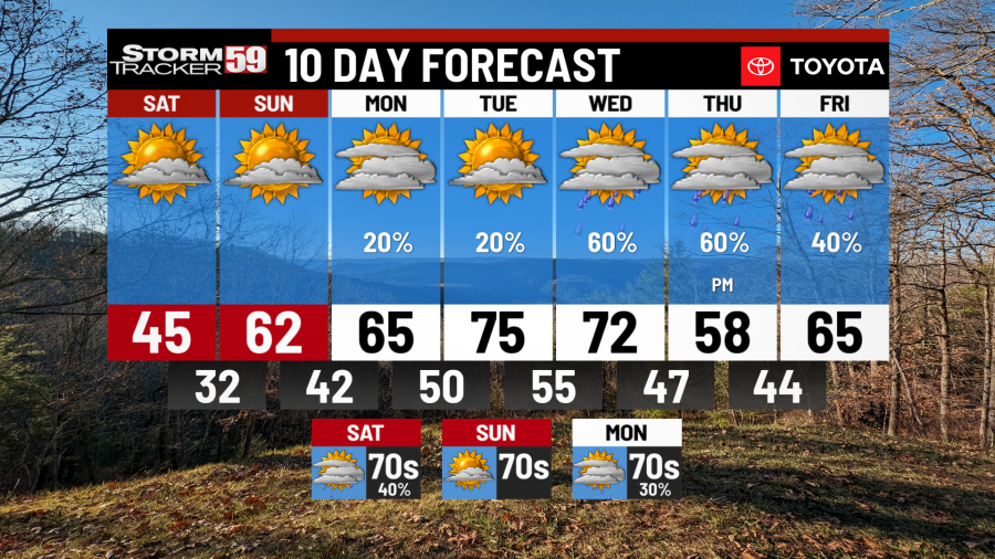
TONIGHT
Periods of drizzle early. Mostly cloudy and cold! Lows in the mid 20s.
SATURDAY
Early clouds. Mostly sunny. Highs in the mid 40s.
SATURDAY NIGHT
Mostly clear. Lows around 30.
SUNDAY
Mostly sunny. Warmer. Highs in the low to mid 60s.
MONDAY
Few isolated showers. Highs in the low to mid 60s.
TUESDAY
Partly sunny. Breezy and warmer. Highs in the mid 70s.
WEDNESDAY
Scattered showers and storms. Highs in the low 70s.
THURSDAY
Showers likely. Cooler. Highs in the mid 50s.
FRIDAY
Early showers. Late day clearing. Highs in the mid 60s.
SATURDAY
Partly sunny. Warmer. Highs in the mid to upper 70s.
SUNDAY
Partly sunny. Highs in the upper 70s.
MONDAY
Gusty showers. Highs in the mid 70s.
Copyright 2026 Nexstar Media, Inc. All rights reserved. This material may not be published, broadcast, rewritten, or redistributed.For the latest news, weather, sports, and streaming video, head to WVNS.


Posting Komentar untuk "Weekend forecast: Chilly Saturday but much warmer Sunday with sunshine"